
Charlie Moreland camping area - Imbil State Forest, Kenilworth, Australia
Basic Info
Address: Sunday Creek Road
Distance from the campground to Kenilworth: 6.79 mi
Amenities & Services
Restroom facilities
Handicap access facilities

Downloadable Map 1 » Charlie Moreland camping area - Imbil State Forest
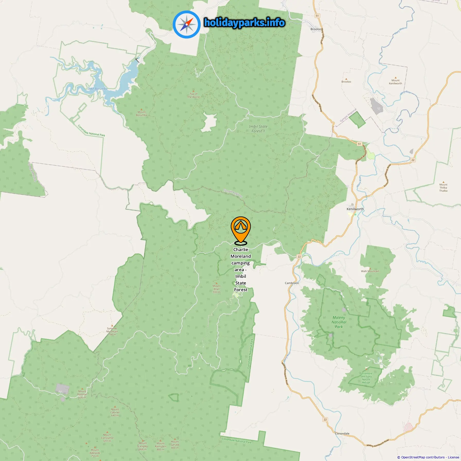
Location of Charlie Moreland camping area - Imbil State Forest

Downloadable Map 2 » Charlie Moreland camping area - Imbil State Forest
Location of Charlie Moreland camping area - Imbil State Forest
More campgrounds in Kenilworth
-
Kenilworth Show & Recreation Ground | SEQ Country Camping Bliss »
0.16 mi from Kenilworth
-
Kenilworth Homestead »
1.45 mi from Kenilworth
-
Parklands Camping Kenilworth »
2.83 mi from Kenilworth
-
Bluff Creek Campground »
3.7 mi from Kenilworth
-
Charlie Moreland camping area - Imbil State Forest »
6.79 mi from Kenilworth
-
Summer Falls (walk-in) camp - Conondale National Park »
9.78 mi from Kenilworth
-
Wongai walkers camp - Conondale National Park »
14.52 mi from Kenilworth
-
Tallowwood walkers camp - Conondale National Park »
15.55 mi from Kenilworth
Find campgrounds in these cities near Kenilworth
Campgrounds in Coolabine (3.76 mi from Kenilworth)
Campgrounds in Gheerulla (3.83 mi from Kenilworth)
Campgrounds in Cambroon (5.13 mi from Kenilworth)
-
Caravan & Camping Park »
0.01 mi from Cambroon
-
Cambroon Caravan Park »
0.07 mi from Cambroon
-
Little Yabba Picnic Area »
1.23 mi from Cambroon
-
Little Yabba Creek Rest Area »
1.26 mi from Cambroon
-
Booloumba Creek camping area 4 - Conondale National Park »
5.15 mi from Cambroon
-
Booloumba Creek camping area 1 - Conondale National Park »
4.16 mi from Cambroon
-
Booloumba Creek camping area 3 - Conondale National Park »
5.35 mi from Cambroon
-
Charlie Moreland Campground »
4.36 mi from Cambroon
-
Summer Falls Walkers Camp »
7.33 mi from Cambroon
Campgrounds in Booloumba (5.91 mi from Kenilworth)
Campgrounds in Bollier (12.75 mi from Kenilworth)
Campgrounds in Mapleton (13.8 mi from Kenilworth)
Campgrounds in Flaxton (17.98 mi from Kenilworth)
Campgrounds in Conondale (13.32 mi from Kenilworth)
Campgrounds in Imbil (12.66 mi from Kenilworth)
-
Imbil Caravan Park »
0.09 mi from Imbil
-
Imbil Showgrounds »
0.58 mi from Imbil
-
Imbil Camping Retreat | Peaceful Camp Along Yabba Creek »
0.22 mi from Imbil
-
Island Reach Caravan Park »
0.21 mi from Imbil
-
Island Reach Camping Resort »
0.21 mi from Imbil
-
Number One Crossing Campground »
2.04 mi from Imbil
-
Borumba Deer Park »
5.56 mi from Imbil
-
Borumba Deer Park »
5.95 mi from Imbil
Campgrounds in Harper Creek (17 mi from Kenilworth)
Campgrounds in Bella Creek (21.55 mi from Kenilworth)
Campgrounds in Maleny (25.01 mi from Kenilworth)
Campgrounds in Eerwah Vale (19.69 mi from Kenilworth)
Campgrounds in Lake Borumba (28.01 mi from Kenilworth)
Campgrounds in Yandina (24.53 mi from Kenilworth)